
Ziethen topographic map
Interactive map
Click on the map to display elevation.
About this map
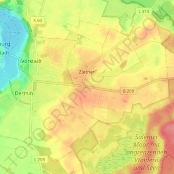
Name: Ziethen topographic map, elevation, terrain.
Average elevation: 138 ft
Minimum elevation: 0 ft
Maximum elevation: 243 ft
Other topographic maps
Click on a map to view its topography, its elevation and its terrain.
Schönberg
Allemagne > Schleswig-Holstein > Herzogtum Lauenburg > Schönberg
Schönberg, Sandesneben-Nusse, Herzogtum Lauenburg, Schleswig-Holstein, Allemagne
Average elevation: 190 ft
Lauenburg/Elbe
Allemagne > Schleswig-Holstein > Herzogtum Lauenburg
Lauenburg/Elbe, Herzogtum Lauenburg, Schleswig-Holstein, 21481, Allemagne
Average elevation: 69 ft