
Make a donation
Gear up for your next adventure:
As an Amazon Associate, this site earns from qualifying purchases at no extra cost to you.
Khaybar topographic map
Click on the map to display elevation.
Make a donation
Gear up for your next adventure:
As an Amazon Associate, this site earns from qualifying purchases at no extra cost to you.
About this map
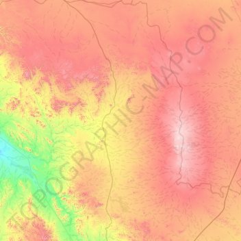
Name: Khaybar topographic map, elevation, terrain.
Location: Khaybar, Medina Province, Saudi Arabia (24.91113 38.42854 26.80400 39.98106)
Average elevation: 3,320 ft
Minimum elevation: 965 ft
Maximum elevation: 6,722 ft
Make a donation
Gear up for your next adventure:
As an Amazon Associate, this site earns from qualifying purchases at no extra cost to you.
Other topographic maps
Click on a map to view its topography, its elevation and its terrain.
Medina
Saudi Arabia > Medina Province
Medina is located in the Hejaz region which is a 200 km (124 mi) wide strip between the Nafud desert and the Red Sea. Located approximately 720 km (447 mi) northwest of Riyadh which is at the center of the Saudi desert, the city is 250 km (155 mi) away from the west coast of Saudi Arabia and at an elevation of…
Average elevation: 2,270 ft
Make a donation
Gear up for your next adventure:
As an Amazon Associate, this site earns from qualifying purchases at no extra cost to you.
Medina
Saudi Arabia > Medina Province
Medina is located in the Hejaz region which is a 200 km (120 mi) wide strip between the Nafud desert and the Red Sea. Located approximately 720 km (450 mi) northwest of Riyadh which is at the center of the Saudi desert, the city is 250 km (160 mi) away from the west coast of Saudi Arabia and at an elevation of…
Average elevation: 2,270 ft
Make a donation
Gear up for your next adventure:
As an Amazon Associate, this site earns from qualifying purchases at no extra cost to you.
Make a donation
Gear up for your next adventure:
As an Amazon Associate, this site earns from qualifying purchases at no extra cost to you.
Make a donation
Gear up for your next adventure:
As an Amazon Associate, this site earns from qualifying purchases at no extra cost to you.
Medina
Saudi Arabia > Medina Province
Medina is located in the Hejaz region which is a 200 km (120 mi) wide strip between the Nafud desert and the Red Sea. Located approximately 720 km (450 mi) northwest of Riyadh which is at the centre of the Saudi desert, the city is 250 km (160 mi) away from the west coast of Saudi Arabia and at an elevation of…
Average elevation: 2,270 ft
Make a donation
Gear up for your next adventure:
As an Amazon Associate, this site earns from qualifying purchases at no extra cost to you.
Make a donation
Gear up for your next adventure:
As an Amazon Associate, this site earns from qualifying purchases at no extra cost to you.
Medina
Saudi Arabia > Medina Province
Medina is located in the Hejaz region which is a 200 km (120 mi) wide strip between the Nafud desert and the Red Sea. Located approximately 720 km (450 mi) northwest of Riyadh which is at the center of the Saudi desert, the city is 250 km (160 mi) away from the west coast of Saudi Arabia and at an elevation of…
Average elevation: 2,270 ft
Make a donation
Gear up for your next adventure:
As an Amazon Associate, this site earns from qualifying purchases at no extra cost to you.
Medina
Saudi Arabia > Medina Province
Medina is located in the Hejaz region which is a 200 km (120 mi) wide strip between the Nafud desert and the Red Sea. Located approximately 720 km (450 mi) northwest of Riyadh which is at the center of the Saudi desert, the city is 250 km (160 mi) away from the west coast of Saudi Arabia and at an elevation of…
Average elevation: 2,270 ft
Make a donation
Gear up for your next adventure:
As an Amazon Associate, this site earns from qualifying purchases at no extra cost to you.
Medina
Saudi Arabia > Medina Province
Medina is located in the Hejaz region which is a 200 km (120 mi) wide strip between the Nafud desert and the Red Sea. Located approximately 720 km (450 mi) northwest of Riyadh which is at the center of the Saudi desert, the city is 250 km (160 mi) away from the west coast of Saudi Arabia and at an elevation of…
Average elevation: 2,270 ft
Make a donation
Gear up for your next adventure:
As an Amazon Associate, this site earns from qualifying purchases at no extra cost to you.
Make a donation
Gear up for your next adventure:
As an Amazon Associate, this site earns from qualifying purchases at no extra cost to you.
Make a donation
Gear up for your next adventure:
As an Amazon Associate, this site earns from qualifying purchases at no extra cost to you.
Make a donation
Gear up for your next adventure:
As an Amazon Associate, this site earns from qualifying purchases at no extra cost to you.