
Scopi topographic map
Interactive map
Click on the map to display elevation.
About this map
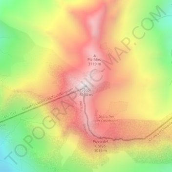
Name: Scopi topographic map, elevation, terrain.
Location: Scopi, Medel (Lucmagn), Surselva, Grigioni, 7185, Svizzera (46.57162 8.82995 46.57172 8.83005)
Average elevation: 8,698 ft
Minimum elevation: 6,604 ft
Maximum elevation: 10,449 ft
Other topographic maps
Click on a map to view its topography, its elevation and its terrain.
Lago di Santa Maria
Svizzera > Grigioni > Medel (Lucmagn)
Lago di Santa Maria, 416, Medel (Lucmagn), Surselva, Grigioni, 7185, Svizzera
Average elevation: 6,837 ft