
East Berne topographic map
Interactive map
Click on the map to display elevation.
About this map
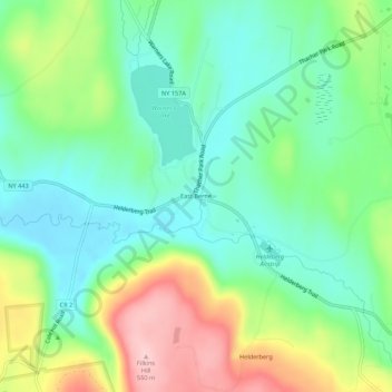
Name: East Berne topographic map, elevation, terrain.
Average elevation: 1,345 ft
Minimum elevation: 1,119 ft
Maximum elevation: 1,795 ft
Other topographic maps
Click on a map to view its topography, its elevation and its terrain.
Thompsons Lake
United States > New York > Albany County > Town of Berne
Thompsons Lake, Town of Berne, Albany County, New York, 12059, United States
Average elevation: 1,339 ft
Reidsville
United States > New York > Albany County > Town of Berne
Reidsville, Town of Berne, Albany County, New York, United States
Average elevation: 1,414 ft
South Berne
United States > New York > Albany County > Town of Berne
South Berne, Town of Berne, Albany County, New York, United States
Average elevation: 1,460 ft
Henry Hill
United States > New York > Albany County > Town of Berne
Henry Hill, Town of Berne, Albany County, New York, United States
Average elevation: 1,969 ft