
Make a donation
Gear up for your next adventure:
As an Amazon Associate, this site earns from qualifying purchases at no extra cost to you.
Bridgeton topographic map
Click on the map to display elevation.
Make a donation
Gear up for your next adventure:
As an Amazon Associate, this site earns from qualifying purchases at no extra cost to you.
About this map
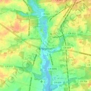
Name: Bridgeton topographic map, elevation, terrain.
Average elevation: 59 ft
Minimum elevation: -10 ft
Maximum elevation: 115 ft
Cumberland County trails, hiking, mountain biking, running and outdoor activities
Make a donation
Gear up for your next adventure:
As an Amazon Associate, this site earns from qualifying purchases at no extra cost to you.
Other topographic maps
Click on a map to view its topography, its elevation and its terrain.
West Creek
United States > New Jersey > Cumberland County > Maurice River Township
Average elevation: 16 ft
Willis Corner
United States > New Jersey > Cumberland County > Stow Creek Township
Average elevation: 36 ft
Greenwich
United States > New Jersey > Cumberland County > Greenwich Township > Greenwich
Average elevation: 7 ft
Make a donation
Gear up for your next adventure:
As an Amazon Associate, this site earns from qualifying purchases at no extra cost to you.