
Make a donation
Gear up for your next adventure:
As an Amazon Associate, this site earns from qualifying purchases at no extra cost to you.
Pine City topographic map
Click on the map to display elevation.
Make a donation
Gear up for your next adventure:
As an Amazon Associate, this site earns from qualifying purchases at no extra cost to you.
About this map
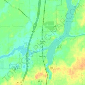
Name: Pine City topographic map, elevation, terrain.
Location: Pine City, Pine County, Minnesota, 55063, United States (45.80641 -92.99131 45.86445 -92.94988)
Average elevation: 958 ft
Minimum elevation: 915 ft
Maximum elevation: 1,020 ft
Pine County trails, hiking, mountain biking, running and outdoor activities
Make a donation
Gear up for your next adventure:
As an Amazon Associate, this site earns from qualifying purchases at no extra cost to you.
Other topographic maps
Click on a map to view its topography, its elevation and its terrain.
Big Pine Lake
United States > Minnesota > Pine County > Pine Lake Township
Average elevation: 1,112 ft