
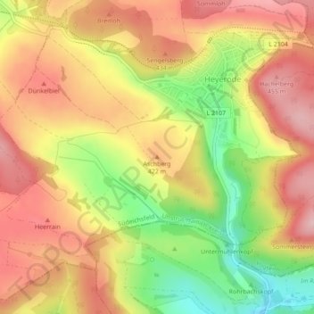
Aschberg topographic map
Interactive map
Click on the map to display elevation.
About this map
Name: Aschberg topographic map, elevation, terrain.
Average elevation: 1,302 ft
Minimum elevation: 965 ft
Maximum elevation: 1,539 ft
Other topographic maps
Click on a map to view its topography, its elevation and its terrain.
Steinacker
Deutschland > Thüringen > Unstrut-Hainich-Kreis > Südeichsfeld
Steinacker, Diedorf, Katharinenberg, Südeichsfeld, Unstrut-Hainich-Kreis, Thüringen, 99988, Deutschland
Average elevation: 1,365 ft
Heyerode
Deutschland > Thüringen > Unstrut-Hainich-Kreis > Südeichsfeld
Heyerode, Südeichsfeld, Unstrut-Hainich-Kreis, Thüringen, 99988, Deutschland
Average elevation: 1,378 ft
Gaiberg
Deutschland > Thüringen > Unstrut-Hainich-Kreis > Südeichsfeld
Gaiberg, Südeichsfeld, Unstrut-Hainich-Kreis, Thüringen, Deutschland
Average elevation: 1,260 ft
Südeichsfeld
Deutschland > Thüringen > Unstrut-Hainich-Kreis > Südeichsfeld
Südeichsfeld, Unstrut-Hainich-Kreis, Thüringen, 99988, Deutschland
Average elevation: 1,289 ft