
Isen topographic map
Interactive map
Click on the map to display elevation.
About this map
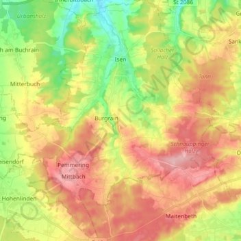
Name: Isen topographic map, elevation, terrain.
Location: Isen, Landkreis Erding, Beieren, 84424, Duitsland (48.13968 12.00211 48.23565 12.11623)
Average elevation: 1,847 ft
Minimum elevation: 1,581 ft
Maximum elevation: 2,106 ft
Other topographic maps
Click on a map to view its topography, its elevation and its terrain.
Lengdorf
Duitsland > Beieren > Landkreis Erding
Lengdorf, Landkreis Erding, Beieren, 84435, Duitsland
Average elevation: 1,640 ft
Eittingermoos
Duitsland > Beieren > Landkreis Erding
Eittingermoos, Eitting, Oberding (VGem), Landkreis Erding, Beieren, 85417, Duitsland
Average elevation: 1,430 ft
Ottenhofen
Duitsland > Beieren > Landkreis Erding
Ottenhofen, Oberneuching (VGem), Landkreis Erding, Beieren, Duitsland
Average elevation: 1,663 ft