
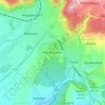
Weidhausen topographic map
Interactive map
Click on the map to display elevation.
About this map
Name: Weidhausen topographic map, elevation, terrain.
Average elevation: 1,355 ft
Minimum elevation: 1,125 ft
Maximum elevation: 1,991 ft
Other topographic maps
Click on a map to view its topography, its elevation and its terrain.
Neuenbau
Deutschland > Thüringen > Landkreis Sonneberg > Föritztal
Neuenbau, Föritztal, Landkreis Sonneberg, Thüringen, 96355, Deutschland
Average elevation: 2,113 ft
Jagdshof
Deutschland > Thüringen > Landkreis Sonneberg > Föritztal
Jagdshof, Föritztal, Landkreis Sonneberg, Thüringen, 96524, Deutschland
Average elevation: 1,798 ft
Judenbach
Deutschland > Thüringen > Landkreis Sonneberg > Föritztal
Judenbach, Föritztal, Landkreis Sonneberg, Thüringen, Deutschland
Average elevation: 1,824 ft