
Msambweni topographic map
Interactive map
Click on the map to display elevation.
About this map
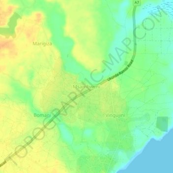
Name: Msambweni topographic map, elevation, terrain.
Location: Msambweni, Kwale, Coastal Kenya, Kenia (-4.47997 39.45687 -4.43997 39.49687)
Average elevation: 52 ft
Minimum elevation: 0 ft
Maximum elevation: 98 ft
Other topographic maps
Click on a map to view its topography, its elevation and its terrain.
Shimba Hills National Reserve
Shimba Hills National Reserve, Kwale - tiribe road, Jiweni, Kwale, Kenia
Average elevation: 600 ft