
Thank you for supporting this site ❤️
Make a donation
Make a donation
Gear up for your next adventure:
As an Amazon Associate, this site earns from qualifying purchases at no extra cost to you.
Middlesbrough topographic map
Click on the map to display elevation.
Thank you for supporting this site ❤️
Make a donation
Make a donation
Gear up for your next adventure:
As an Amazon Associate, this site earns from qualifying purchases at no extra cost to you.
About this map
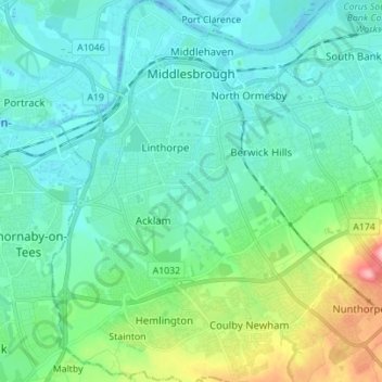
Name: Middlesbrough topographic map, elevation, terrain.
Location: Middlesbrough, Tees Valley, England, United Kingdom (54.51076 -1.28250 54.59140 -1.16067)
Average elevation: 85 ft
Minimum elevation: -43 ft
Maximum elevation: 430 ft
Thank you for supporting this site ❤️
Make a donation
Make a donation
Gear up for your next adventure:
As an Amazon Associate, this site earns from qualifying purchases at no extra cost to you.