Geolocate

Livingston topographic map

Click on the map to display elevation.

About this map

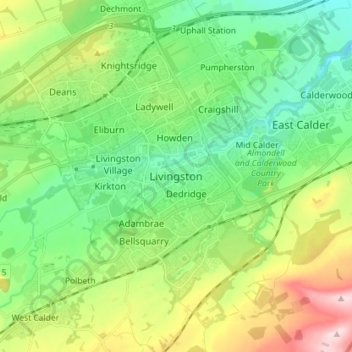
Name: Livingston topographic map, elevation, terrain.

Location: Livingston, West Lothian, Scotland, EH54 6HS, United Kingdom (55.84319 -3.55495 55.92319 -3.47495)

Average elevation: 518 ft

Minimum elevation: 220 ft

Maximum elevation: 1,152 ft

Gear up for your next adventure:

🧦Hiking Socks - Comfortable socks to prevent blisters on long hikes
📡GPS Antenna Upgrade - Enhance GPS reception in remote terrain
🛡️Bear Spray Outdoor - Protection in bear country hikes
🔌Solar Panel Charger - Charge gear sustainably outdoors
🪶Thermal Camp Blanket - Extra warmth for cold nights

As an Amazon Associate, this site earns from qualifying purchases at no extra cost to you.