
São Luís topographic map
Interactive map
Click on the map to display elevation.
About this map
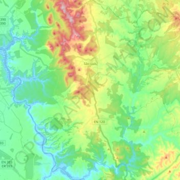
Name: São Luís topographic map, elevation, terrain.
Location: São Luís, Odemira, Beja, Portugal (37.62088 -8.75415 37.76845 -8.57016)
Average elevation: 348 ft
Minimum elevation: -23 ft
Maximum elevation: 1,168 ft
Other topographic maps
Click on a map to view its topography, its elevation and its terrain.
Serva
Portugal > Beja > Odemira > São Martinho das Amoreiras
Serva, São Martinho das Amoreiras, Odemira, Beja, 7630-521, Portugal
Average elevation: 679 ft
Aldeia Nova de Cima
Aldeia Nova de Cima, São Salvador e Santa Maria, Odemira, Beja, 7630-128, Portugal
Average elevation: 200 ft
Luzianes-Gare
Luzianes-Gare, Odemira, Beja, 7665-891, Portugal
Average elevation: 509 ft