
Winterthour topographic map
Interactive map
Click on the map to display elevation.
About this map
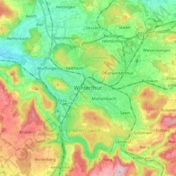
Name: Winterthour topographic map, elevation, terrain.
Location: Winterthour, Bezirk Winterthur, Zurich, Suisse (47.44972 8.65661 47.54800 8.80994)
Average elevation: 1,654 ft
Minimum elevation: 1,280 ft
Maximum elevation: 2,283 ft
Other topographic maps
Click on a map to view its topography, its elevation and its terrain.
Hettlingen
Suisse > Zurich > Bezirk Winterthur
Hettlingen, Bezirk Winterthur, Zurich, 8442, Suisse
Average elevation: 1,467 ft