
Point England topographic map
Interactive map
Click on the map to display elevation.
About this map
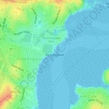
Name: Point England topographic map, elevation, terrain.
Average elevation: 36 ft
Minimum elevation: -3 ft
Maximum elevation: 144 ft
Other topographic maps
Click on a map to view its topography, its elevation and its terrain.
One Tree Hill
New Zealand > Auckland > Maungakiekie-Tamaki
One Tree Hill, Maungakiekie-Tāmaki, Auckland, 1051, New Zealand
Average elevation: 266 ft
Mount Wellington
New Zealand > Auckland > Maungakiekie-Tamaki
Mount Wellington, Maungakiekie-Tamaki, Auckland, 1741, New Zealand
Average elevation: 105 ft