
Camargo topographic map
Interactive map
Click on the map to display elevation.
About this map
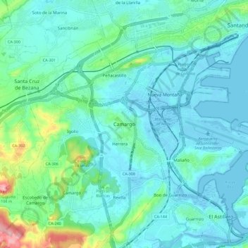
Name: Camargo topographic map, elevation, terrain.
Location: Camargo, Cantabria, 39600, España (43.39010 -3.90163 43.47010 -3.82163)
Average elevation: 105 ft
Minimum elevation: -16 ft
Maximum elevation: 614 ft
Other topographic maps
Click on a map to view its topography, its elevation and its terrain.
Cueva de los Murciélagos
Cueva de los Murciélagos, Calle de Camargo Somavilla, Camargo, Comarca de Santander, Cantabria, 39609, España
Average elevation: 157 ft