
Demirtaş topographic map
Interactive map
Click on the map to display elevation.
About this map
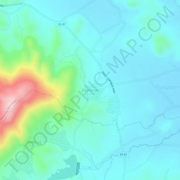
Name: Demirtaş topographic map, elevation, terrain.
Location: Demirtaş, Dikili, Izmir, Aegean Region, Turkey (38.98182 26.92403 39.02182 26.96403)
Average elevation: 223 ft
Minimum elevation: 26 ft
Maximum elevation: 1,115 ft
Other topographic maps
Click on a map to view its topography, its elevation and its terrain.
Denizköy Mahallesi
Turkey > Dikili > Denizköy Mahallesi
Denizköy Mahallesi, Dikili, Izmir, Aegean Region, 35980, Turkey
Average elevation: 446 ft