
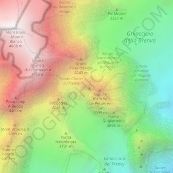
Aiguille Blanche de Peuterey topographic map
Interactive map
Click on the map to display elevation.
About this map
Name: Aiguille Blanche de Peuterey topographic map, elevation, terrain.
Location: Aiguille Blanche de Peuterey, Courmayeur, Valle d'Aosta, Italia (45.82352 6.88100 45.82362 6.88110)
Average elevation: 11,896 ft
Minimum elevation: 8,586 ft
Maximum elevation: 15,761 ft
Other topographic maps
Click on a map to view its topography, its elevation and its terrain.
Val Veny
Italia > Valle d'Aosta > Courmayeur
Val Veny, Courmayeur, Valle d'Aosta, Italia
Average elevation: 7,057 ft
Peuterey
Italia > Valle d'Aosta > Courmayeur
Peuterey, Courmayeur, Valle d'Aosta, 11013, Italia
Average elevation: 6,345 ft
Pic Eccles
Italia > Valle d'Aosta > Courmayeur
Pic Eccles, Courmayeur, Valle d'Aosta, Italia
Average elevation: 12,090 ft
Ghiacciaio del Miage
Italia > Valle d'Aosta > Courmayeur
Ghiacciaio del Miage, Sentiero 15 Rifugio Gonella, Courmayeur, Valle d'Aosta, Italia
Average elevation: 9,551 ft
Grand Pilier d'Angle
Italia > Valle d'Aosta > Courmayeur
Grand Pilier d'Angle, Courmayeur, Valle d'Aosta, Italia
Average elevation: 12,402 ft