
Make a donation
Gear up for your next adventure:
As an Amazon Associate, this site earns from qualifying purchases at no extra cost to you.
Hergiswil (NW) topographic map
Click on the map to display elevation.
Make a donation
Gear up for your next adventure:
As an Amazon Associate, this site earns from qualifying purchases at no extra cost to you.
About this map
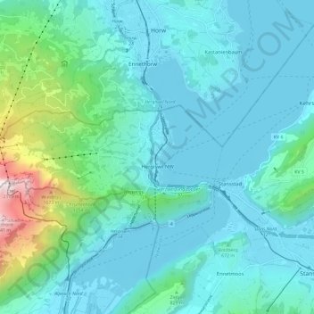
Name: Hergiswil (NW) topographic map, elevation, terrain.
Location: Hergiswil (NW), Nidwalden, 6052, Switzerland (46.97315 8.21809 46.99957 8.33445)
Average elevation: 2,218 ft
Minimum elevation: 1,385 ft
Maximum elevation: 6,870 ft
Make a donation
Gear up for your next adventure:
As an Amazon Associate, this site earns from qualifying purchases at no extra cost to you.
Other topographic maps
Click on a map to view its topography, its elevation and its terrain.
ewl Ausgleichsbecken Untertrübsee
Switzerland > Nidwalden > Wolfenschiessen
Average elevation: 4,783 ft
Bürgenstock
Switzerland > Nidwalden > Ennetbürgen
On the Dufourkarte (Dufour Map), the topographic map of Switzerland from 1844 to 1864, the mountain ridge as a whole had no name. The highest crest was referred to as Hametschwand.
Average elevation: 2,103 ft
Make a donation
Gear up for your next adventure:
As an Amazon Associate, this site earns from qualifying purchases at no extra cost to you.