Geolocate

Albox topographic map

Click on the map to display elevation.

About this map

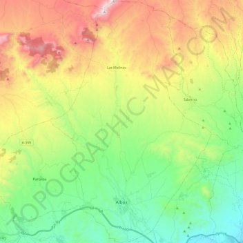
Name: Albox topographic map, elevation, terrain.

Location: Albox, Valle del Almanzora, Almeria, Andalusia, 04800, Spain (37.35596 -2.21641 37.54576 -2.05704)

Average elevation: 2,320 ft

Minimum elevation: 778 ft

Maximum elevation: 4,895 ft

Other topographic maps

Click on a map to view its topography, its elevation and its terrain.

Mirador de Cosentino

Spain > Andalusia > Valle del Almanzora > Macael

Average elevation: 2,667 ft

Las Pocicas

Spain > Andalusia > Valle del Almanzora > Albox

Average elevation: 2,559 ft

Gear up for your next adventure:

🧭Map Reading Tools - Tools and kits for map navigation
🔥Fast-Boil Camping Stoves - Efficient cooking systems for quick trail meals
🧣Hiking Neck Gaiter - Multi‑use neck protection for outdoor weather
🍳Camping Cook Set - Complete cookware for outdoor meals
🧼Biodegradable Camping Soap - Eco‑friendly soap for outdoor hygiene

As an Amazon Associate, this site earns from qualifying purchases at no extra cost to you.