Geolocate

Falkenberg topographic map

Click on the map to display elevation.

About this map

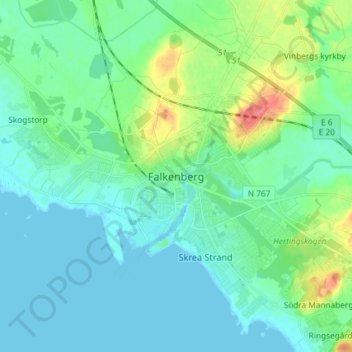
Name: Falkenberg topographic map, elevation, terrain.

Location: Falkenberg, Falkenbergs kommun, Halland County, 311 21, Sweden (56.86489 12.45129 56.94489 12.53129)

Average elevation: 43 ft

Minimum elevation: -3 ft

Maximum elevation: 200 ft

Other topographic maps

Click on a map to view its topography, its elevation and its terrain.

Gällarpesjön

Sweden > Halland County

Average elevation: 341 ft

Laholms kommun

Sweden > Halland County

Average elevation: 322 ft

Vendelsö

Sweden > Halland County

Average elevation: 7 ft

Hylte kommun

Sweden > Halland County

Average elevation: 476 ft

Halmstads kommun

Sweden > Halland County

Average elevation: 213 ft

Bocksjö

Sweden > Halland County

Average elevation: 246 ft

Kungsbacka kommun

Sweden > Halland County

Average elevation: 135 ft

Tjolöholms slott

Sweden > Halland County

Average elevation: 10 ft

Varbergs kommun

Sweden > Halland County

Average elevation: 115 ft

Gear up for your next adventure:

🪑Ultralight Camp Chairs - Portable seating for resting after a long day of mapping
🛡️Bear Spray Outdoor - Protection in bear country hikes
🛶Inflatable Kayak - Portable kayak for rivers, lakes, and expeditions
🧦Merino Wool Socks - Moisture-wicking, blister-preventing socks for long treks
🥾Men's Hiking Boots - Durable, waterproof footwear for rugged terrain and steep inclines

As an Amazon Associate, this site earns from qualifying purchases at no extra cost to you.