
Make a donation
Gear up for your next adventure:
As an Amazon Associate, this site earns from qualifying purchases at no extra cost to you.
Miles City topographic map
Click on the map to display elevation.
Make a donation
Gear up for your next adventure:
As an Amazon Associate, this site earns from qualifying purchases at no extra cost to you.
About this map
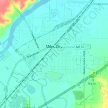
Name: Miles City topographic map, elevation, terrain.
Location: Miles City, Custer County, Montana, 59301, United States (46.38294 -105.86553 46.42780 -105.81047)
Average elevation: 2,375 ft
Minimum elevation: 2,333 ft
Maximum elevation: 2,605 ft
Custer County trails, hiking, mountain biking, running and outdoor activities
Make a donation
Gear up for your next adventure:
As an Amazon Associate, this site earns from qualifying purchases at no extra cost to you.
Other topographic maps
Click on a map to view its topography, its elevation and its terrain.
Carbon Hill Trailer Court
United States > Montana > Custer County > Miles City
Average elevation: 2,402 ft
Cook Lake
United States > Montana > Custer County > Miles City > Smiths Trailer Court
Average elevation: 2,365 ft