
Make a donation
Gear up for your next adventure:
As an Amazon Associate, this site earns from qualifying purchases at no extra cost to you.
Osorno topographic map
Click on the map to display elevation.
Make a donation
Gear up for your next adventure:
As an Amazon Associate, this site earns from qualifying purchases at no extra cost to you.
Osorno
Osorno's proximity to the Cardenal Antonio Samoré Pass makes it a key place the national economy. The mountain pass connects Osorno to the Argentine city of Bariloche, and is one of primary arteries that ties the two countries' southern regions together. The pass is particularly important due to the fact that it crosses the Andes mountains at very low altitude, allowing it to remain open even when other passes are blocked by snow.
Make a donation
Gear up for your next adventure:
As an Amazon Associate, this site earns from qualifying purchases at no extra cost to you.
About this map
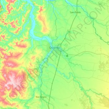
Name: Osorno topographic map, elevation, terrain.
Location: Osorno, Provincia de Osorno, Los Lagos Region, Chile (-40.78834 -73.41798 -40.41942 -72.76827)
Average elevation: 344 ft
Minimum elevation: 0 ft
Maximum elevation: 1,289 ft
Make a donation
Gear up for your next adventure:
As an Amazon Associate, this site earns from qualifying purchases at no extra cost to you.
Other topographic maps
Click on a map to view its topography, its elevation and its terrain.
Río Cholguaco
Chile > Los Lagos Region > Provincia de Osorno > Río Negro > Caleta Cóndor
Average elevation: 335 ft