
Peace River topographic map
Interactive map
Click on the map to display elevation.
About this map
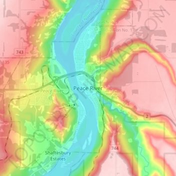
Name: Peace River topographic map, elevation, terrain.
Location: Peace River, Division No. 19, Alberta, T8S 1P7, Canada (56.19371 -117.33108 56.27371 -117.25108)
Average elevation: 1,421 ft
Minimum elevation: 1,010 ft
Maximum elevation: 1,808 ft
Other topographic maps
Click on a map to view its topography, its elevation and its terrain.
Clairmont
Canada > Alberta > Division No. 19 > Hamlet of Clairmont
Clairmont, Hamlet of Clairmont, Division No. 19, Alberta, T0H 0W0, Canada
Average elevation: 2,228 ft