
Lavey-les-Bains topographic map
Interactive map
Click on the map to display elevation.
About this map
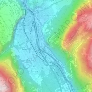
Name: Lavey-les-Bains topographic map, elevation, terrain.
Average elevation: 2,467 ft
Minimum elevation: 1,302 ft
Maximum elevation: 5,545 ft
Other topographic maps
Click on a map to view its topography, its elevation and its terrain.
Mauvoisin
Suisse > Vaud > Lavey-Morcles > Lavey-les-Bains
Mauvoisin, Lavey-les-Bains, Lavey-Morcles, District d'Aigle, Vaud, 1890, Suisse
Average elevation: 1,883 ft