
Kokshetau topographic map
Interactive map
Click on the map to display elevation.
About this map
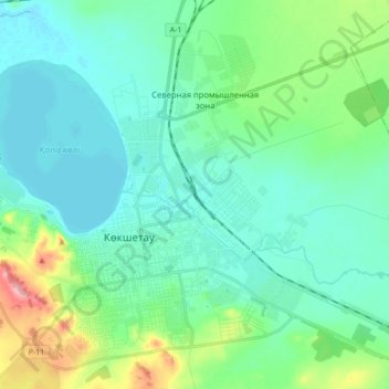
Name: Kokshetau topographic map, elevation, terrain.
Location: Kokshetau, Кокшетау Г.А., Akmola Region, 020000, Kazakhstan (53.25046 69.28667 53.34202 69.46434)
Average elevation: 820 ft
Minimum elevation: 719 ft
Maximum elevation: 1,171 ft
Kokshetau, Kökshetaū (meaning Blue Mountain in Kazakh, Kazakh: Көкшетау, romanized: Kókshetaý; (listen), Russian: Кокшета́у, pronounced ), formerly known as Kokchetav (Russian: Кокчета́в, IPA: ) (1827–1993), is a city in northern Kazakhstan and the capital of Akmola Region, lying in the north of Kokshetau hills, on the southern shores of Lake Kopa and the southern edge of the Esil (Ishim) Steppe. It is also situated at the junction of the Trans-Kazakhstan and South Siberian railways. Kokshetau lies at an elevation of approximately 234 m (768 ft) above sea level.