
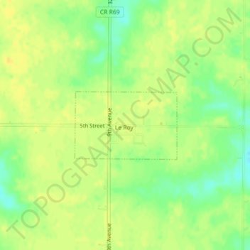
Le Roy topographic map
Interactive map
Click on the map to display elevation.
About this map
Name: Le Roy topographic map, elevation, terrain.
Location: Le Roy, Decatur County, Iowa, United States (40.87430 -93.59997 40.88164 -93.58538)
Average elevation: 1,106 ft
Minimum elevation: 1,056 ft
Maximum elevation: 1,132 ft
Other topographic maps
Click on a map to view its topography, its elevation and its terrain.
Decatur City
United States > Iowa > Decatur County
Decatur City, Decatur County, Iowa, 50067, United States
Average elevation: 1,096 ft
Van Wert
United States > Iowa > Decatur County
Van Wert, Decatur County, Iowa, United States
Average elevation: 1,135 ft
Pleasanton
United States > Iowa > Decatur County
Pleasanton, Decatur County, Iowa, United States
Average elevation: 1,050 ft
Davis City
United States > Iowa > Decatur County
Davis City, Decatur County, Iowa, 50065, United States
Average elevation: 922 ft
Leon
United States > Iowa > Decatur County
Leon, Decatur County, Iowa, 50144, United States
Average elevation: 1,086 ft
Garden Grove
United States > Iowa > Decatur County
Garden Grove, Decatur County, Iowa, United States
Average elevation: 1,079 ft
Weldon
United States > Iowa > Decatur County
Weldon, Decatur County, Iowa, United States
Average elevation: 1,135 ft
Lamoni
United States > Iowa > Decatur County
Lamoni, Decatur County, Iowa, 50140, United States
Average elevation: 1,119 ft
Grand River
United States > Iowa > Decatur County
Grand River, Decatur County, Iowa, United States
Average elevation: 1,027 ft