
Island of Montreal topographic map
Interactive map
Click on the map to display elevation.
About this map
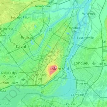
Name: Island of Montreal topographic map, elevation, terrain.
Average elevation: 98 ft
Minimum elevation: -30 ft
Maximum elevation: 751 ft
Other topographic maps
Click on a map to view its topography, its elevation and its terrain.
Saint Lawrence River
Saint Lawrence River, Rue De Gaspé, Verdun, Montreal, Urban agglomeration of Montreal, Montreal (06), Quebec, H3E 1H2, Canada
Average elevation: 46 ft
Parc Émilie-Gamelin
Parc Émilie-Gamelin, René-Lévesque, Ville-Marie, Montreal, Urban agglomeration of Montreal, Montreal (06), Quebec, Canada
Average elevation: 108 ft
Parc Lady-Alys-Robi
Parc Lady-Alys-Robi, Louis-Riel, Montreal, Urban agglomeration of Montreal, Montreal (06), Quebec, Canada
Average elevation: 141 ft
Côte-des-Neiges–Notre-Dame-de-Grâce
Côte-des-Neiges–Notre-Dame-de-Grâce, Montreal, Urban agglomeration of Montreal, Montreal (06), Quebec, Canada
Average elevation: 223 ft
Le Sud-Ouest
Le Sud-Ouest, Montreal, Urban agglomeration of Montreal, Montreal (06), Quebec, Canada
Average elevation: 138 ft
Saint-Laurent
Saint-Laurent, Montreal, Urban agglomeration of Montreal, Montreal (06), Quebec, Canada
Average elevation: 112 ft
Ville-Marie
Ville-Marie, Montreal, Urban agglomeration of Montreal, Montreal (06), Quebec, Canada
Average elevation: 98 ft