
Make a donation
Gear up for your next adventure:
As an Amazon Associate, this site earns from qualifying purchases at no extra cost to you.
Ashton-under-Lyne topographic map
Click on the map to display elevation.
Make a donation
Gear up for your next adventure:
As an Amazon Associate, this site earns from qualifying purchases at no extra cost to you.
Ashton-under-Lyne
At 53°29′38″N 2°6′11″W / 53.49389°N 2.10306°W / 53.49389; -2.10306 (53.4941°, −2.1032°), and 160 miles (257 km) north-northwest of London, Ashton-under-Lyne stands on the north bank of the River Tame, about 35 feet (11 m) above the river. Described in Samuel Lewis's A Topographical Dictionary of England (1848) as situated "on a gentle declivity", Ashton-under-Lyne lies on undulating ground by the Pennines, reaching a maximum elevation of about 1,000 feet (305 m) above sea level. It is 6.2 miles (10.0 km) east of Manchester city centre, and is bound on all sides by other towns: Audenshaw, Droylsden, Dukinfield, Mossley, Oldham, and Stalybridge, with little or no green space between them. Ashton experiences a temperate maritime climate, like much of the British Isles.
Make a donation
Gear up for your next adventure:
As an Amazon Associate, this site earns from qualifying purchases at no extra cost to you.
About this map
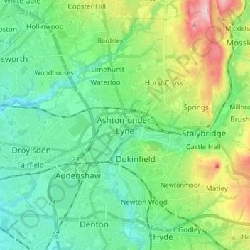
Name: Ashton-under-Lyne topographic map, elevation, terrain.
Average elevation: 423 ft
Minimum elevation: 207 ft
Maximum elevation: 1,004 ft
Make a donation
Gear up for your next adventure:
As an Amazon Associate, this site earns from qualifying purchases at no extra cost to you.