
Piz Umbrail topographic map
Interactive map
Click on the map to display elevation.
About this map
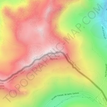
Name: Piz Umbrail topographic map, elevation, terrain.
Average elevation: 8,678 ft
Minimum elevation: 7,021 ft
Maximum elevation: 9,885 ft
Other topographic maps
Click on a map to view its topography, its elevation and its terrain.
Cima la Casina
Svizzera > Grigioni > Val Müstair
Cima la Casina, Val Müstair, Regione Engiadina Bassa/Val Müstair, Grigioni, Svizzera
Average elevation: 8,816 ft