
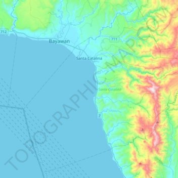
Santa Catalina topographic map
Interactive map
Click on the map to display elevation.
About this map
Name: Santa Catalina topographic map, elevation, terrain.
Average elevation: 518 ft
Minimum elevation: -3 ft
Maximum elevation: 3,281 ft
The topography of Santa Catalina is predominantly slightly rolling hills (70% of its area), 25% is flat, and the remainder is steep terrain. There are 8 rivers and 27 springs.