
Puerto Saavedra topographic map
Interactive map
Click on the map to display elevation.
About this map
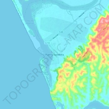
Name: Puerto Saavedra topographic map, elevation, terrain.
Average elevation: 56 ft
Minimum elevation: 0 ft
Maximum elevation: 417 ft
Other topographic maps
Click on a map to view its topography, its elevation and its terrain.
Comunidad Trancito Llancaleo
Chile > Región de la Araucanía > Provincia de Cautín > Saavedra
Comunidad Trancito Llancaleo, Saavedra, Provincia de Cautín, Región de la Araucanía, Chile
Average elevation: 144 ft