
Taufkirchen an der Pram topographic map
Interactive map
Click on the map to display elevation.
About this map
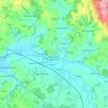
Name: Taufkirchen an der Pram topographic map, elevation, terrain.
Location: Taufkirchen an der Pram, Bezirk Schärding, 4775, Österreich (48.37769 13.48654 48.44802 13.56815)
Average elevation: 1,217 ft
Minimum elevation: 1,040 ft
Maximum elevation: 1,867 ft
Taufkirchen an der Pram liegt auf 338 m Höhe im Innviertel. Die Ausdehnung beträgt von Nord nach Süd 7,9 km, von West nach Ost 6 km. Die Gesamtfläche beträgt 29,2 km², 11,6 % der Fläche sind bewaldet, 78,8 % der Fläche sind landwirtschaftlich genutzt.
Other topographic maps
Click on a map to view its topography, its elevation and its terrain.
Vichtenstein
Vichtenstein, Bezirk Schärding, 4091, Österreich
Average elevation: 1,808 ft
Andorf
Andorf, Bezirk Schärding, 4770, Österreich
Average elevation: 1,224 ft
Münzkirchen
Münzkirchen, Bezirk Schärding, 4792, Österreich
Average elevation: 1,627 ft
Enzenkirchen
Enzenkirchen, Bezirk Schärding, 4761, Österreich
Average elevation: 1,434 ft
Schärding
Schärding, Bezirk Schärding, 4780, Österreich
Average elevation: 1,060 ft
Kopfing im Innkreis
Kopfing im Innkreis, Bezirk Schärding, 4794, Österreich
Average elevation: 1,831 ft