Geolocate

Rushbrooke topographic map

Interactive map

Click on the map to display elevation.

About this map

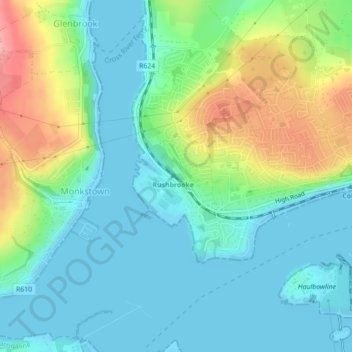
Name: Rushbrooke topographic map, elevation, terrain.

Location: Rushbrooke, Cobh Urban, Cobh, County Cork, Munster, T12 TW44, Ireland (51.83951 -8.33204 51.85951 -8.31204)

Average elevation: 98 ft

Minimum elevation: -7 ft

Maximum elevation: 338 ft

Other topographic maps

Click on a map to view its topography, its elevation and its terrain.

Cork Harbour

Ireland > Cobh

Cork Harbour, The Valley Road, Ballymore, Cobh Rural, Cobh, County Cork, Munster, P25A062, Ireland

Average elevation: 10 ft

Ballyadam

Ireland > Cobh

Ballyadam, Carrigtohill, Cobh, County Cork, Munster, Ireland

Average elevation: 112 ft

Kilgarvan

Ireland > Cobh

Kilgarvan, Cobh Urban, Cobh, County Cork, Munster, Ireland

Average elevation: 105 ft

Castleview

Ireland > Cobh

Castleview, Caherlag, Cobh, County Cork, Munster, T45 KW40, Ireland

Average elevation: 102 ft

Dunkettle

Ireland > Cobh

Dunkettle, Caherlag, Cobh, Cork City 2019, County Cork, Munster, T45 NW94, Ireland

Average elevation: 121 ft

Dromgarriff

Ireland > Cobh

Dromgarriff, Blackpool, Cobh, County Cork, Munster, Ireland

Average elevation: 541 ft

Riverstown

Ireland > Cobh

Riverstown, Cobh, County Cork, Munster, Ireland

Average elevation: 387 ft

Belvelly

Ireland > Cobh

Belvelly, Cobh Rural, Cobh, County Cork, Munster, T45 K590, Ireland

Average elevation: 79 ft