Geolocate

Makawao topographic map

Click on the map to display elevation.

About this map

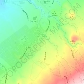
Name: Makawao topographic map, elevation, terrain.

Location: Makawao, Maui County, Hawaii, 96768, United States (20.83003 -156.34403 20.87215 -156.30157)

Average elevation: 1,522 ft

Minimum elevation: 922 ft

Maximum elevation: 2,362 ft

Maui County trails, hiking, mountain biking, running and outdoor activities

Gear up for your next adventure:

🪵Folding Camp Saw - Compact saw for wood and campsite work
🌡️Handheld Weather Meters - Measure wind, temp, and pressure for safe mountain travel
🚗GPS Dash Cams - Record your scenic drives through mountain passes and canyons
📖Nature Tracking Books - Learn to track wildlife and terrain
🔥Camping Stove - Portable stove for camping and backcountry cooking

As an Amazon Associate, this site earns from qualifying purchases at no extra cost to you.