
Cuero topographic map
Interactive map
Click on the map to display elevation.
About this map
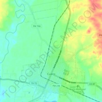
Name: Cuero topographic map, elevation, terrain.
Location: Cuero, DeWitt County, Texas, 77954, United States (29.07458 -97.31307 29.14401 -97.26403)
Average elevation: 213 ft
Minimum elevation: 151 ft
Maximum elevation: 344 ft
Other topographic maps
Click on a map to view its topography, its elevation and its terrain.
Garfield
United States > Texas > DeWitt County
Garfield, DeWitt County, Texas, United States
Average elevation: 446 ft
Yorktown
United States > Texas > DeWitt County
Yorktown, DeWitt County, Texas, United States
Average elevation: 295 ft
Stratton
United States > Texas > DeWitt County
Stratton, DeWitt County, Texas, United States
Average elevation: 285 ft
Concrete
United States > Texas > DeWitt County
Concrete, DeWitt County, Texas, United States
Average elevation: 262 ft
Thomaston
United States > Texas > DeWitt County
Thomaston, DeWitt County, Texas, 77989, United States
Average elevation: 161 ft
Cuero
United States > Texas > DeWitt County > Cuero
Cuero, DeWitt County, Texas, 77954, United States
Average elevation: 200 ft