
Reservorio de Tinajones topographic map
Interactive map
Click on the map to display elevation.
About this map
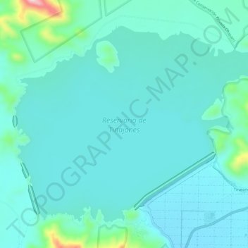
Name: Reservorio de Tinajones topographic map, elevation, terrain.
Average elevation: 705 ft
Minimum elevation: 561 ft
Maximum elevation: 1,558 ft
Other topographic maps
Click on a map to view its topography, its elevation and its terrain.
Batan Grande
Perú > Lambayeque > Chongoyape
Batan Grande, Chongoyape, Chiclayo, Lambayeque, Perú
Average elevation: 659 ft
Reservorio de Tinajones
Perú > Lambayeque > Chongoyape
Reservorio de Tinajones, Chongoyape, Provincia de Chiclayo, Lambayeque, Perú
Average elevation: 705 ft
Río Chancay
Perú > Lambayeque > Chongoyape
Río Chancay, Chongoyape, Provincia de Chiclayo, Lambayeque, Perú
Average elevation: 673 ft