
East Berlin topographic map
Click on the map to display elevation.
About this map
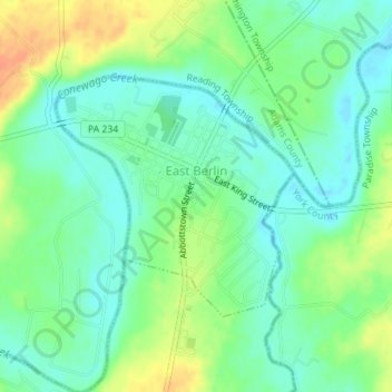
Name: East Berlin topographic map, elevation, terrain.
Location: East Berlin, Adams County, Pennsylvania, United States (39.92757 -76.99122 39.94408 -76.96979)
Average elevation: 436 ft
Minimum elevation: 387 ft
Maximum elevation: 518 ft
Adams County trails, hiking, mountain biking, running and outdoor activities
Other topographic maps
Click on a map to view its topography, its elevation and its terrain.
Raven Rock Mountain
United States > Pennsylvania > Adams County > Liberty Township
Average elevation: 1,024 ft
Gladhill (Greenstone P.O.)
United States > Pennsylvania > Adams County > Hamiltonban Township
Average elevation: 1,198 ft