Geolocate

Wivenhoe topographic map

Click on the map to display elevation.

About this map

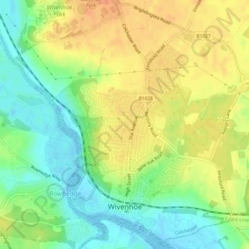
Name: Wivenhoe topographic map, elevation, terrain.

Location: Wivenhoe, Rowhedge, Colchester, Essex, England, United Kingdom (51.85132 0.93929 51.87752 0.97937)

Average elevation: 72 ft

Minimum elevation: -3 ft

Maximum elevation: 135 ft

Gear up for your next adventure:

🥄Camping Utensil Set - Lightweight utensils for outdoor meals
🛶Inflatable Kayak - Portable kayak for rivers, lakes, and expeditions
⛑️Personal Locator Beacon - Safety beacon for emergencies
🪵Folding Camp Saw - Compact saw for wood and campsite work
🎒Hydration Pack - Hands‑free water reservoir for long hikes

As an Amazon Associate, this site earns from qualifying purchases at no extra cost to you.