
Reichwalde topographic map
Interactive map
Click on the map to display elevation.
About this map
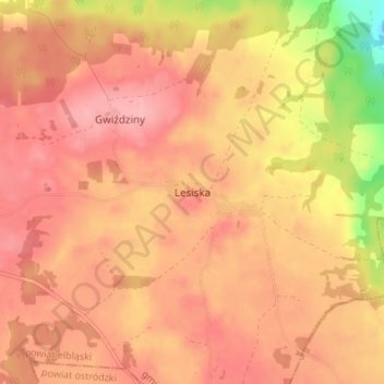
Name: Reichwalde topographic map, elevation, terrain.
Average elevation: 430 ft
Minimum elevation: 171 ft
Maximum elevation: 541 ft
Other topographic maps
Click on a map to view its topography, its elevation and its terrain.
Czarna Góra
Polen > Woiwodschaft Ermland-Masuren > powiat elbląski
Czarna Góra, gmina Pasłęk, powiat elbląski, Woiwodschaft Ermland-Masuren, 14-400, Polen
Average elevation: 305 ft
Warszewo
Polen > Woiwodschaft Ermland-Masuren > powiat elbląski > Warszewo
Warszewo, gmina Młynary, powiat elbląski, Woiwodschaft Ermland-Masuren, 14-420, Polen
Average elevation: 308 ft
Lenzen
Polen > Woiwodschaft Ermland-Masuren > powiat elbląski > Lenzen
Lenzen, gmina Tolkmicko, powiat elbląski, Woiwodschaft Ermland-Masuren, 82-340, Polen
Average elevation: 354 ft