
Drymen topographic map
Interactive map
Click on the map to display elevation.
About this map
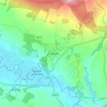
Name: Drymen topographic map, elevation, terrain.
Location: Drymen, Stirling, Scotland, G63 0BJ, United Kingdom (56.04553 -4.47200 56.08553 -4.43200)
Average elevation: 194 ft
Minimum elevation: 26 ft
Maximum elevation: 610 ft
Other topographic maps
Click on a map to view its topography, its elevation and its terrain.
Loch Katrine
United Kingdom > Scotland > Stirling
Loch Katrine, Stirling, Scotland, United Kingdom
Average elevation: 1,145 ft
Ben Lomond
United Kingdom > Scotland > Stirling
Ben Lomond, Stirling, Scotland, G63 0AR, United Kingdom
Average elevation: 1,886 ft