
Titirangi topographic map
Interactive map
Click on the map to display elevation.
About this map
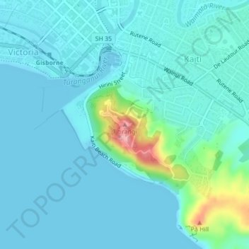
Name: Titirangi topographic map, elevation, terrain.
Location: Titirangi, Gisborne, 4020, New Zealand (-38.67758 178.03117 -38.67748 178.03127)
Average elevation: 62 ft
Minimum elevation: 0 ft
Maximum elevation: 436 ft
Other topographic maps
Click on a map to view its topography, its elevation and its terrain.
Makauri
New Zealand > Gisborne > Gisborne
Makauri, Gisborne, 4071, New Zealand
Average elevation: 33 ft