Geolocate

Naila topographic map

Click on the map to display elevation.

About this map

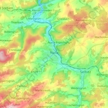
Name: Naila topographic map, elevation, terrain.

Location: Naila, Landkreis Hof, Bavaria, 95119, Germany (50.28421 11.62567 50.37247 11.74208)

Average elevation: 1,906 ft

Minimum elevation: 1,572 ft

Maximum elevation: 2,405 ft

Other topographic maps

Click on a map to view its topography, its elevation and its terrain.

Stegenwaldhaus

Germany > Bavaria > Landkreis Hof > Selbitz

Average elevation: 1,923 ft

Rudolphstein

Germany > Bavaria > Landkreis Hof

Average elevation: 1,703 ft

Carlsgrün

Germany > Bavaria > Landkreis Hof > Bad Steben

Average elevation: 2,008 ft

Gear up for your next adventure:

🧭Pro Hiking Compasses - High-accuracy liquid-filled compasses for topographic orientation
📶Vehicle Signal Boosters - Improve reception in rural areas while driving to trailheads
📷Action Camera - Capture your outdoor adventures in HD
🔌USB Car Charger - Car charger for on‑the‑go power needs
🥘Titanium Cookware - Durable, featherlight pots and pans for backpacking

As an Amazon Associate, this site earns from qualifying purchases at no extra cost to you.