
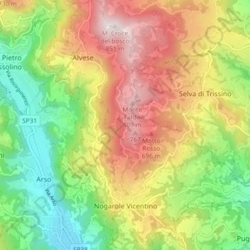
Nogarole Vicentino topographic map
Interactive map
Click on the map to display elevation.
About this map
Name: Nogarole Vicentino topographic map, elevation, terrain.
Average elevation: 1,555 ft
Minimum elevation: 600 ft
Maximum elevation: 2,713 ft
Other topographic maps
Click on a map to view its topography, its elevation and its terrain.
Camisano Vicentino
Camisano Vicentino, Vicence, Vénétie, 36043, Italie
Average elevation: 89 ft
Campedello
Italie > Vénétie > Vicence > Vicence
Campedello, Vicence, Arcugnano, Vicence, Vénétie, 36100, Italie
Average elevation: 151 ft
Bassano del Grappa
Bassano del Grappa, Colceresa, Vicence, Vénétie, 36061, Italie
Average elevation: 738 ft