
Thank you for supporting this site ❤️
Make a donation
Make a donation
Gear up for your next adventure:
As an Amazon Associate, this site earns from qualifying purchases at no extra cost to you.
Potosí topographic map
Click on the map to display elevation.
Thank you for supporting this site ❤️
Make a donation
Make a donation
Gear up for your next adventure:
As an Amazon Associate, this site earns from qualifying purchases at no extra cost to you.
About this map
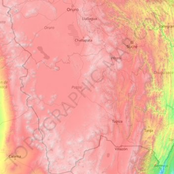
Name: Potosí topographic map, elevation, terrain.
Location: Potosí, Bolivia (-22.89827 -68.77382 -17.80086 -64.71463)
Average elevation: 11,099 ft
Minimum elevation: 1,263 ft
Maximum elevation: 20,738 ft
Thank you for supporting this site ❤️
Make a donation
Make a donation
Gear up for your next adventure:
As an Amazon Associate, this site earns from qualifying purchases at no extra cost to you.
Other topographic maps
Click on a map to view its topography, its elevation and its terrain.
Achiras
Bolivia > Chuquisaca > Provincia Belisario Boeto > Municipio Villa Serrano
Average elevation: 6,076 ft