
Thank you for supporting this site ❤️
Make a donation
Make a donation
Gear up for your next adventure:
As an Amazon Associate, this site earns from qualifying purchases at no extra cost to you.
Mansfeld topographic map
Click on the map to display elevation.
Thank you for supporting this site ❤️
Make a donation
Make a donation
Gear up for your next adventure:
As an Amazon Associate, this site earns from qualifying purchases at no extra cost to you.
About this map
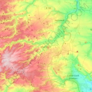
Name: Mansfeld topographic map, elevation, terrain.
Location: Mansfeld, Mansfeld-Südharz, Saxony-Anhalt, 06343, Germany (51.52793 11.19806 51.66171 11.51536)
Average elevation: 794 ft
Minimum elevation: 318 ft
Maximum elevation: 1,329 ft
Thank you for supporting this site ❤️
Make a donation
Make a donation
Gear up for your next adventure:
As an Amazon Associate, this site earns from qualifying purchases at no extra cost to you.
Other topographic maps
Click on a map to view its topography, its elevation and its terrain.