
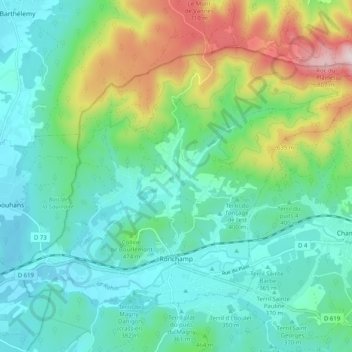
Ronchamp topographic map
Interactive map
Click on the map to display elevation.
About this map
Name: Ronchamp topographic map, elevation, terrain.
Average elevation: 1,457 ft
Minimum elevation: 1,037 ft
Maximum elevation: 2,667 ft
Ronchamp liegt am Fuß der Vogesen in einer Höhenlage von 353 Meter. Zusammen mit acht Nachbarorten bildet Ronchamp das territoire de la Communauté de Communes Rahin et Chérimont (wörtlich: „Gebiet der Gemeinschaftsgemeinden Rahin und Chérimont“) mit insgesamt ca. 12.000 Einwohnern. Das Gemeindegebiet von Ronchamp ist Teil des Regionalen Naturparks Ballons des Vosges.
Other topographic maps
Click on a map to view its topography, its elevation and its terrain.
Betoncourt-lès-Ménétriers
Frankreich > Burgund und Freigrafschaft > Haute-Saône > La Roche-Morey
Betoncourt-lès-Ménétriers, La Roche-Morey, Vesoul, Haute-Saône, Burgund und Freigrafschaft, Metropolitanes Frankreich, Frankreich
Average elevation: 860 ft