
Rostock topographic map
Click on the map to display elevation.
About this map
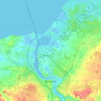
Name: Rostock topographic map, elevation, terrain.
Location: Rostock, Mecklenburg-Vorpommern, Germany (54.05081 11.99837 54.24448 12.29540)
Average elevation: 46 ft
Minimum elevation: -13 ft
Maximum elevation: 226 ft
Other topographic maps
Click on a map to view its topography, its elevation and its terrain.
Neu Darbein
Germany > Mecklenburg-Vorpommern > Mecklenburgische Seenplatte > Dargun
Average elevation: 85 ft
Neu-Grambow
Germany > Mecklenburg-Vorpommern > Vorpommern-Greifswald > Grambow
Average elevation: 125 ft
Heiligendamm
Germany > Mecklenburg-Vorpommern > Landkreis Rostock > Bad Doberan
Average elevation: 26 ft
Liebenthal
Germany > Mecklenburg-Vorpommern > Vorpommern-Greifswald > Gützkow
Average elevation: 33 ft
Neperstorf
Germany > Mecklenburg-Vorpommern > Nordwestmecklenburg > Jesendorf
Average elevation: 154 ft
Pfalz
Germany > Mecklenburg-Vorpommern > Mecklenburgische Seenplatte > Bartow
Average elevation: 69 ft
Valluhn
Germany > Mecklenburg-Vorpommern > Ludwigslust-Parchim > Lüttow-Valluhn
Average elevation: 105 ft
Riemserort
Germany > Mecklenburg-Vorpommern > Vorpommern-Greifswald > Greifswald
Average elevation: 3 ft
Bohnenwerder
Germany > Mecklenburg-Vorpommern > Mecklenburgische Seenplatte > Carwitz
Average elevation: 299 ft
Greifswald
Germany > Mecklenburg-Vorpommern > Vorpommern-Greifswald > Greifswald > Greifswald
Average elevation: 20 ft
Löcknitz
Germany > Mecklenburg-Vorpommern > Vorpommern-Greifswald > Löcknitz > Löcknitz
Average elevation: 43 ft