
Thank you for supporting this site ❤️
Make a donation
Make a donation
Gear up for your next adventure:
As an Amazon Associate, this site earns from qualifying purchases at no extra cost to you.
Nyon topographic map
Click on the map to display elevation.
Thank you for supporting this site ❤️
Make a donation
Make a donation
Gear up for your next adventure:
As an Amazon Associate, this site earns from qualifying purchases at no extra cost to you.
About this map
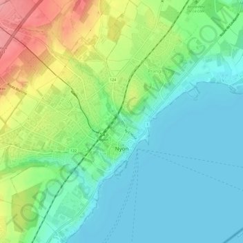
Name: Nyon topographic map, elevation, terrain.
Location: Nyon, District de Nyon, Vaud, 1260, Switzerland (46.36042 6.20570 46.40640 6.26808)
Average elevation: 1,319 ft
Minimum elevation: 1,207 ft
Maximum elevation: 1,585 ft
Thank you for supporting this site ❤️
Make a donation
Make a donation
Gear up for your next adventure:
As an Amazon Associate, this site earns from qualifying purchases at no extra cost to you.
Other topographic maps
Click on a map to view its topography, its elevation and its terrain.
Mont-le-Vieux
Switzerland > Vaud > District de Nyon > Essertines-sur-Rolle
Average elevation: 2,096 ft