
Blackville topographic map
Interactive map
Click on the map to display elevation.
About this map
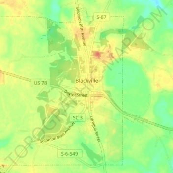
Name: Blackville topographic map, elevation, terrain.
Average elevation: 279 ft
Minimum elevation: 207 ft
Maximum elevation: 344 ft
Other topographic maps
Click on a map to view its topography, its elevation and its terrain.
Barnwell
United States > South Carolina > Barnwell County
Barnwell, Barnwell County, South Carolina, 29812, United States
Average elevation: 210 ft
Elko
United States > South Carolina > Barnwell County
Elko, Barnwell County, South Carolina, United States
Average elevation: 325 ft
Barnwell State Park
United States > South Carolina > Barnwell County > Blackville
Barnwell State Park, Blackville, Barnwell County, South Carolina, United States
Average elevation: 276 ft
Williston
United States > South Carolina > Barnwell County
Williston, Barnwell County, South Carolina, 29853, United States
Average elevation: 335 ft
Hilda
United States > South Carolina > Barnwell County
Hilda, Barnwell County, South Carolina, 29813, United States
Average elevation: 256 ft
Barnwell State Park
United States > South Carolina > Barnwell County
Barnwell State Park, Barnwell County, South Carolina, 29817, United States
Average elevation: 272 ft
Barnwell
United States > South Carolina > Barnwell County > Barnwell
Barnwell, Barnwell County, South Carolina, 29812, United States
Average elevation: 213 ft
Snelling
United States > South Carolina > Barnwell County
Snelling, Barnwell County, South Carolina, United States
Average elevation: 240 ft